


Bridging The Gap
The Future of Innovation in Zhengzhou
with Miao Zhang
Bridging the Gap, The Future of Innovation in Zhenghzhou” studies the potential of certain urban gaps, or under-developed plot of land, left during Zhengzhou rapid urban development, and their potential redevelopment to support the city’s innovative industries. More specifically we propose an innovation park, located on the East side of the city. Our project, stemming from a thorough corpus of research and analysis, is an attempt at revitalizing the in-between spaces of East Zhengzhou, through innovation.
I – Zhengzhou: A city of gaps
Looking at aerial images of Zhengzhou from the past 30 years, we witness the city’s rapid expansion. As to qualify this growth, we defined the urban edge as the outermost limit of the city and map the evolution of this edge. At the same time, we can notice some interesting spots on the maps. These spots are in fact pieces of land which seem either underdeveloped or inconsistent with their surrounding neighborhoods. We coined down these discrepancies as “urban gaps”. These gaps can be seen in every satellite maps, as we draw over them. By tracing the gaps on different satellite images, we noticed their disappearance in newer ones. At the same time, some new gaps emerge.
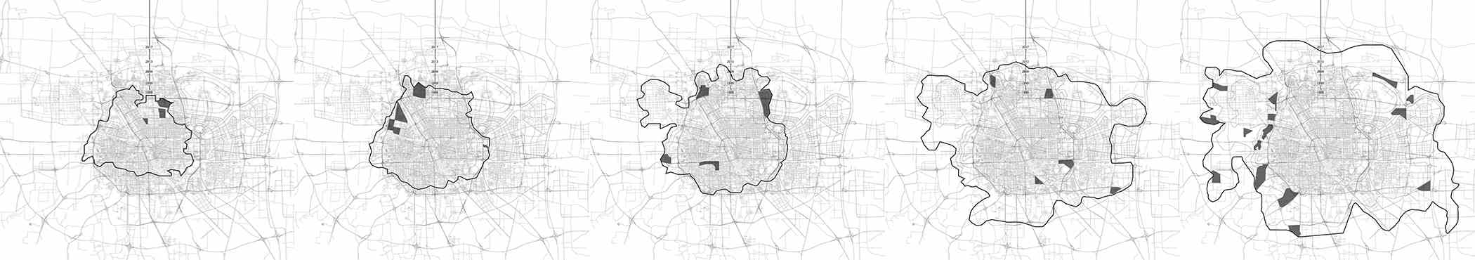
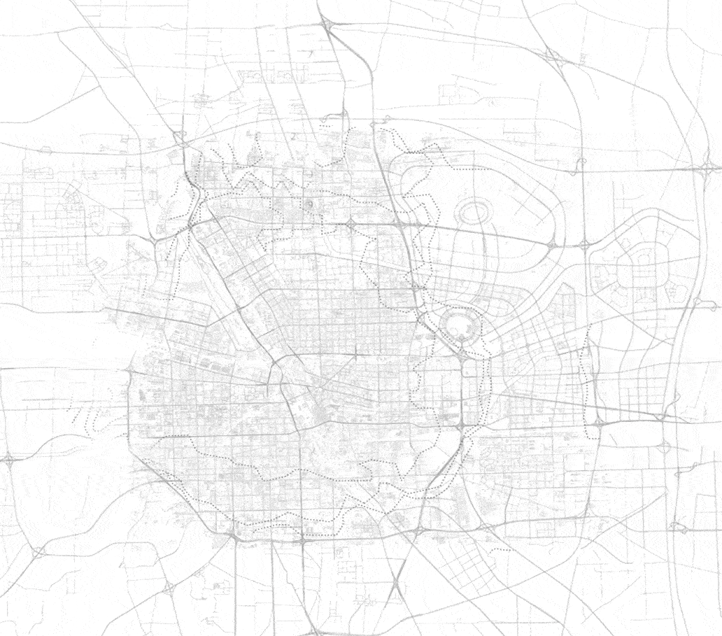
Aware of the imprecision associated with simple “eye-balling” drawing, we chose another way to discover the gaps using density and land-use sections of the city. We sliced Zhengzhou from North to South and from West to East, to finally generate some urban sections, showing the land-use and density of the city. At this point, it is much easier to describe the gaps we previously found. Furthering our analysis, we realized some section along line 3 and 12, following the same process of land-use and density mapping. These sections are in fact the most revealing documents we produced: the urban gaps are even more legible on them. The most typical examples would be the discrepancies on both sides of the university city. In a nutshell, Zhengzhou appears to be a city with lots of discrepancies in terms of urban context due to its uneven and large-development-driven growth from the past 30 years.
Filling The Gap Through Innovation
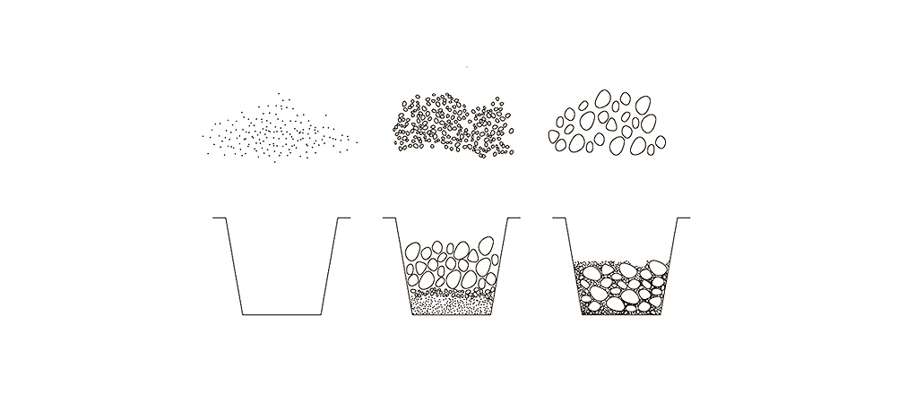
Aside from this very bottom-up approach, our group decided to take a new stance, to understand the urban significance and origin of these encountered gaps. Most Chinese cities are in fact the result of a sedimentation process, where large mega-blocks and vast layers of infrastructures are superimposed on top of a thinner and more granular historical urban fabric. This superposition of layers results in spaces being left behind, located between major development projects. Similarly, to a bucket than one would fill with rocks of different sizes, the rapid urbanization of Zhengzhou very much resembles a bucket being filled sequentially, where larger rock -large development projects- would have been added ex-post, leaving between them significant gaps. Our approach and critique stem from this simple observation: our proposal for Zhengzhou is to pour a thinner “grout”, to fill the gap left between large developments, that would bind and connect some mega projects together.
Looking at Zhengzhou and using the land use map that our studio created we noticed that the main large-scale development projects were in fact driven by 3 main types program: academia, business, and industry. Which led us to look for a meaningful placeholder that could fill the gap between them, while offering a program, that would relate to these 3 programs. An innovation park seemed the most appropriate answer. Not only does technological innovation binds the expertise of industry, business, and academia as it is in Zhengzhou, but it also finds its deeper roots in the city’s long history of innovative manufacture and industry.
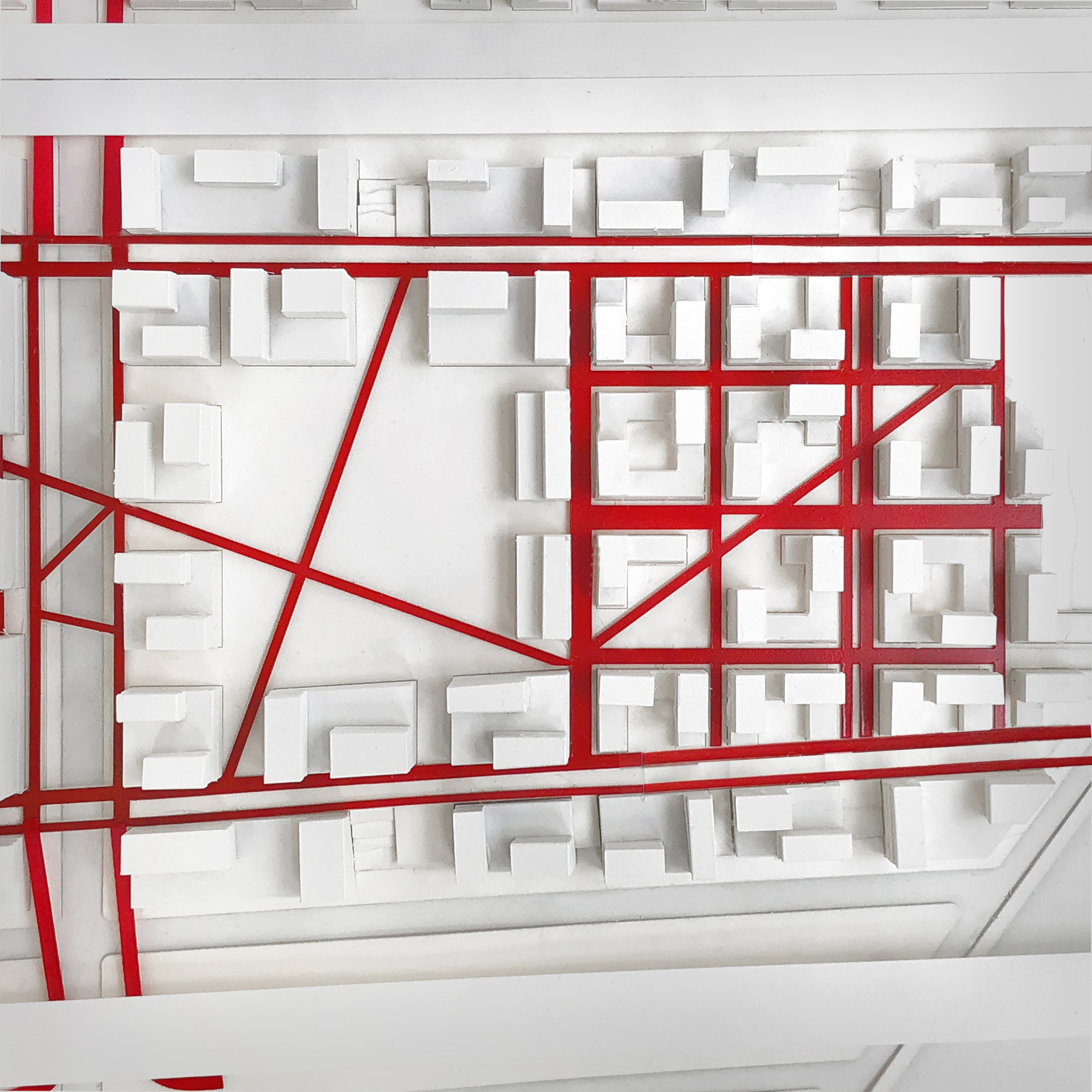
II - Site Selection & Analysis: Line 4 & East Zhengzhou
Land Use Scanner
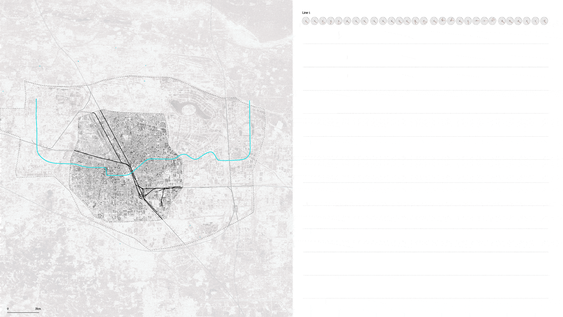
From recognizing the existence of urban gaps within the urban fabric to the selection of a meaningful place for an innovation park, there is a quantum leap. We decided to create a rigorous strategy to scan the city, to find the ideal site. As the studio invited us to study Zhengzhou through the lens of its metro system, we crafted a tool -a Grasshopper plugin- to scan the neighborhood of each station forecasted in the next 15 years, looking for the 3 key programs previously mentioned (industry, business, and academia), and the existence of large underdeveloped plot of land (urban gaps).
The Land Use Scanner, that we scripted over the course of the Studio’s first weeks, proved to be essential: for each metro station, it would output a radial diagram, informing the user on the surrounding land use in a radius of 500 meters, while offering and rough idea of the ratio of each program, to the others. This process systematically applied to all stations allowed us to narrow down the search from than 200 stations to 4.
From 4 to 1 Site
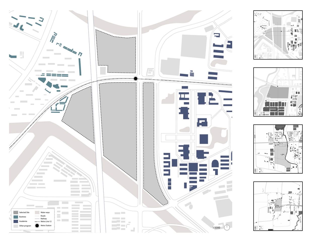
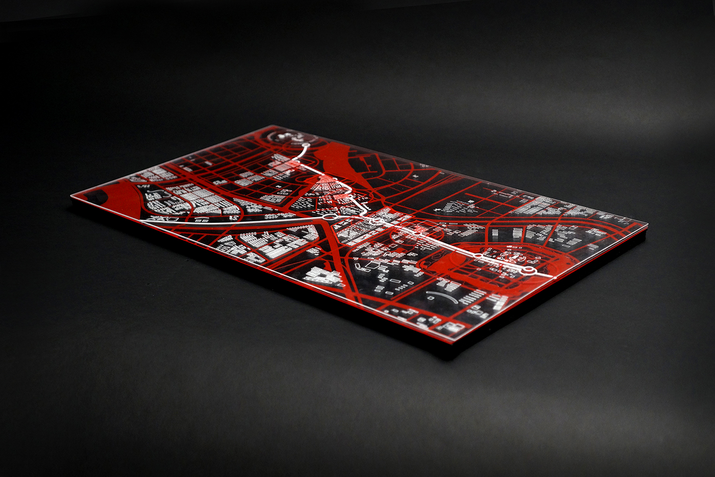
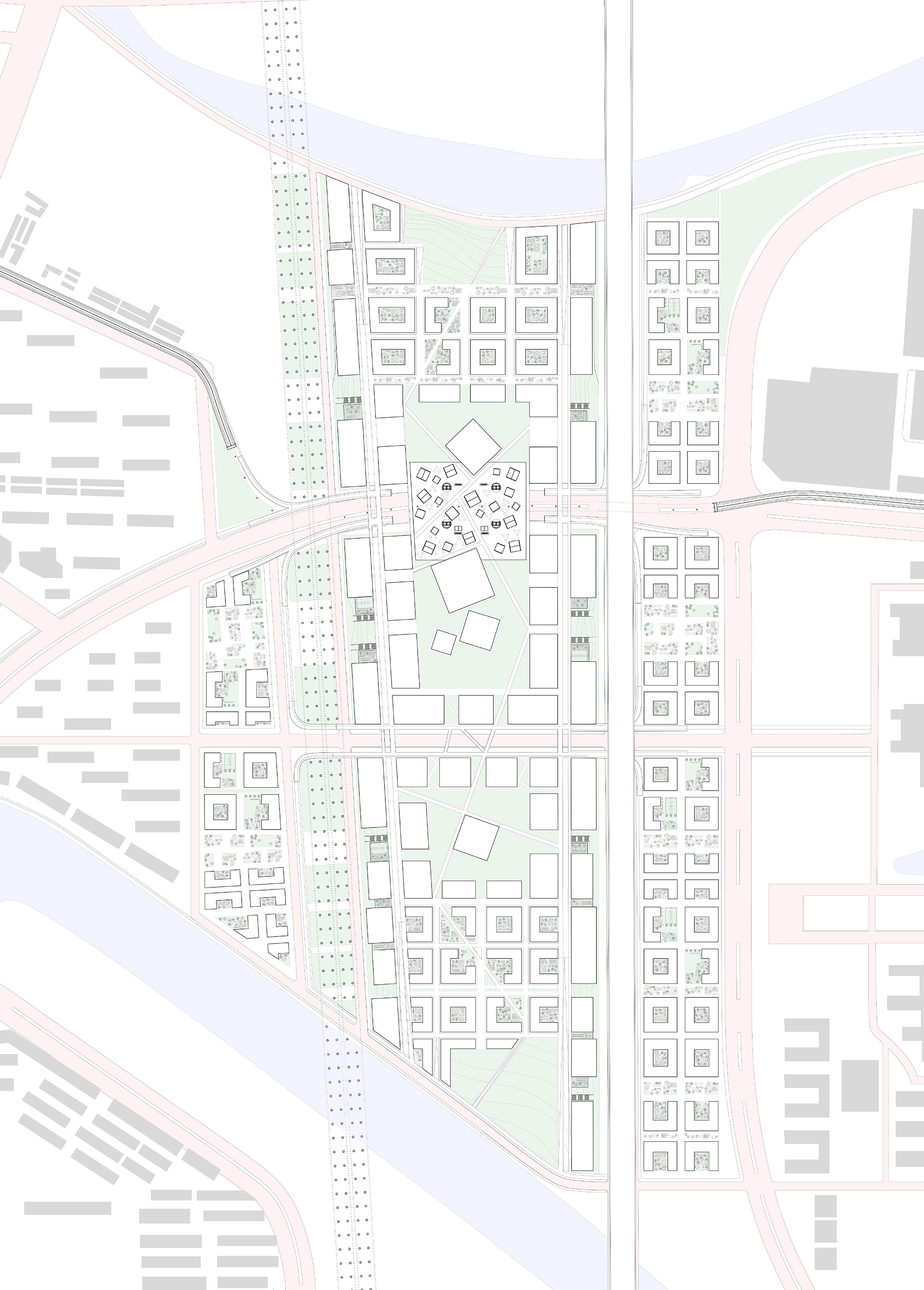
Each one of the 4 remaining stations was initially an ideal candidate to host an innovation district. However, after a more in-depth study, the site located between Longhu CBD to the Longzihu University city stroke us as being the most promising option. Not only does this place have a large undeveloped plot of land, stretched between the railway and two lanes of elevated highways, but it also is located between 2 crucial mega-projects: the new CBD at its Westside, and the University City on its East side. The Metro Line 12 will soon stop right in the middle of the parcel, and therefore connect the place to the city at large.
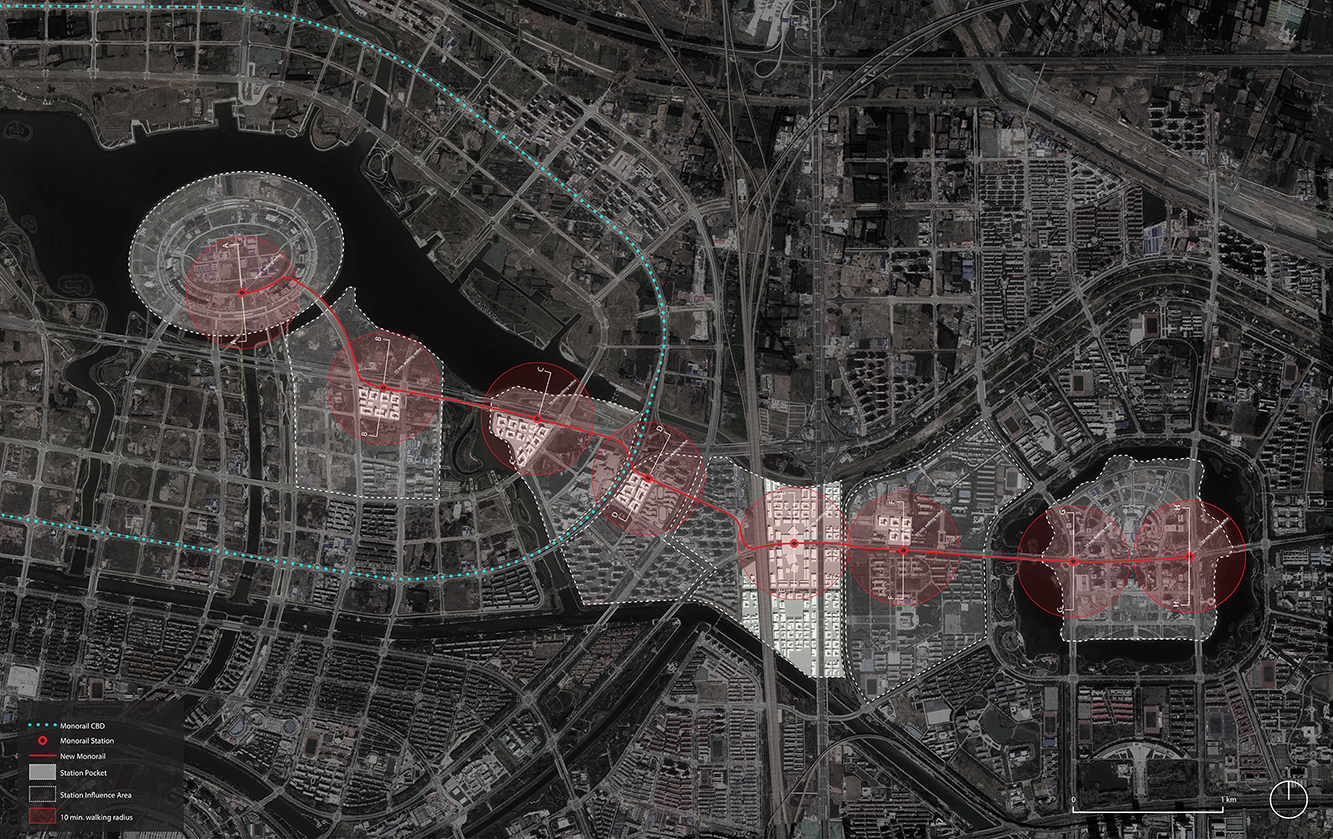
At the scale of the city, this site also offers the opportunity to alleviate what we discovered as being a transportation challenge for Zhenghzou: the metro system relies heavily in the East on Line 4, working as a literal backbone. Line 12 then branches out from the old CBD, located at the South of our site to connect to the Longzihu University City. The remaining issue is the lack of connectivity between the new CBD of Longhu and the University City. This “V-shaped” metro system remains an issue today, and will not be solved in the future, as the planned metro lines (8 and 4) will not solve the connection between the two sites. This is where our proposal could bring a sustainable solution: we would like to offer a lightweight transportation system, a monorail, connecting Longhu CBD and the University City, creating along the way 5 to 6 “pockets” of innovation. The monorail would offer the opportunity to create both more cross-connectivity between these two areas while offering a belt of innovation along the way. The monorail would, of course, be connected to the metro system, first at its start in the CBD (Metro line 4), then on our site (Metro Line 12), and finally at the final station in the University City.
In a nutshell, our project is threefold: from the resolution of the connectivity issue at the urban scale, to the design of the innovation pockets, and finally to the planning of a large innovation park on our site, this project leverages many scales, to offer a complete answer.
III – Design proposal: Innovation Park
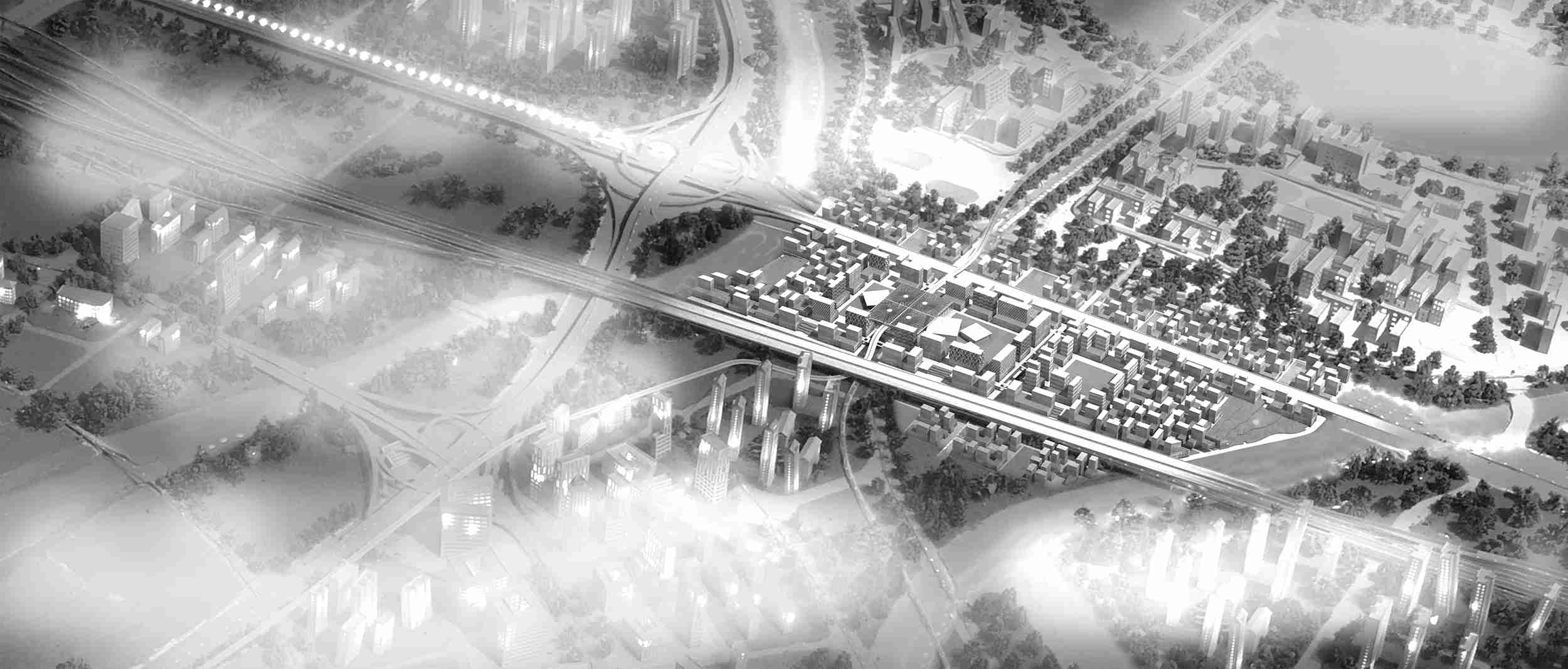
Innovation Pockets & Monorail
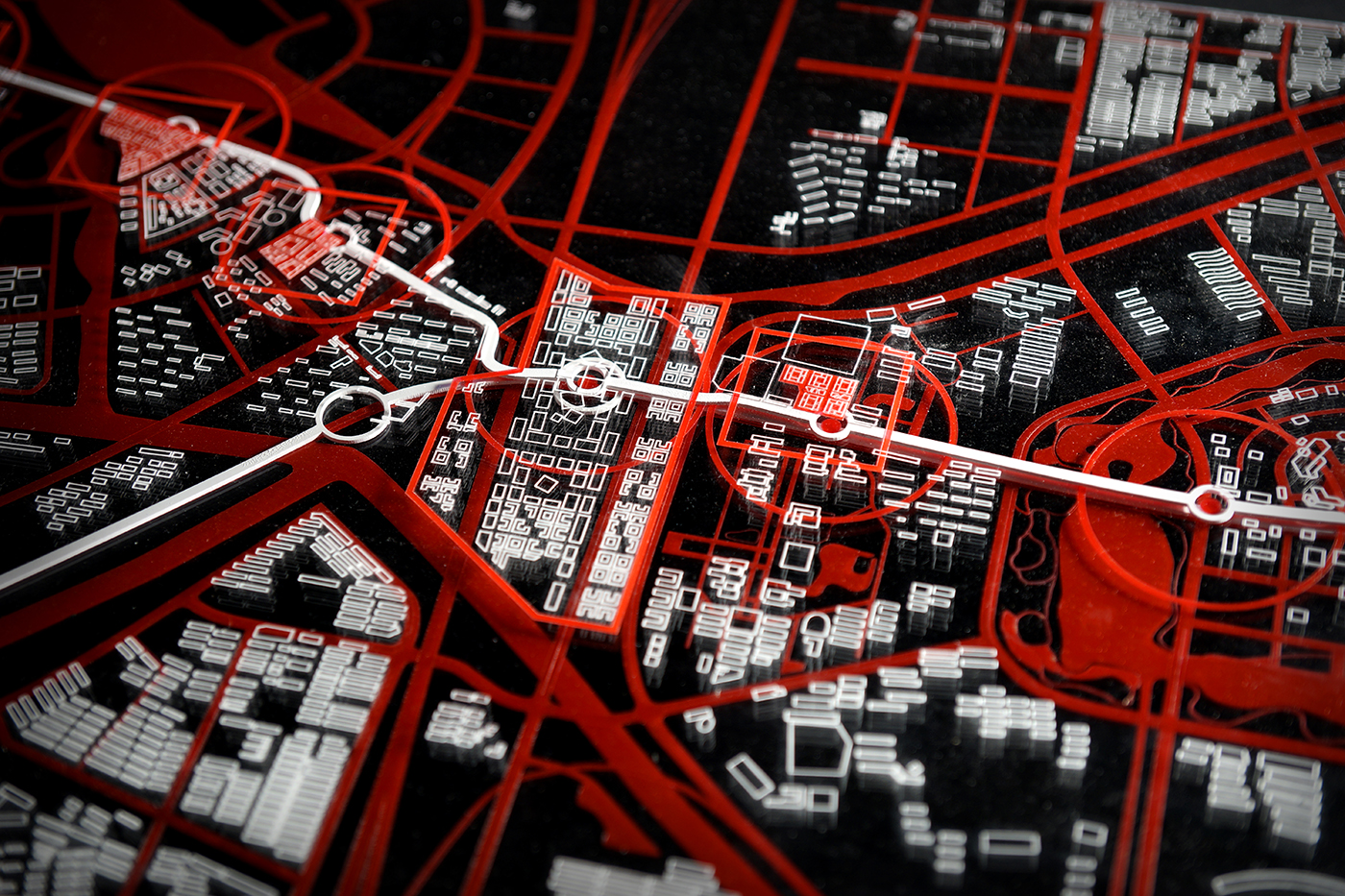
Through systematic sections of the urban fabric between the CBD and the University City, we first defined the ideal path for the monorail. Its trace passes through key gaps and respects the pre-existing infrastructure while running along the current pedestrian and bike lanes.
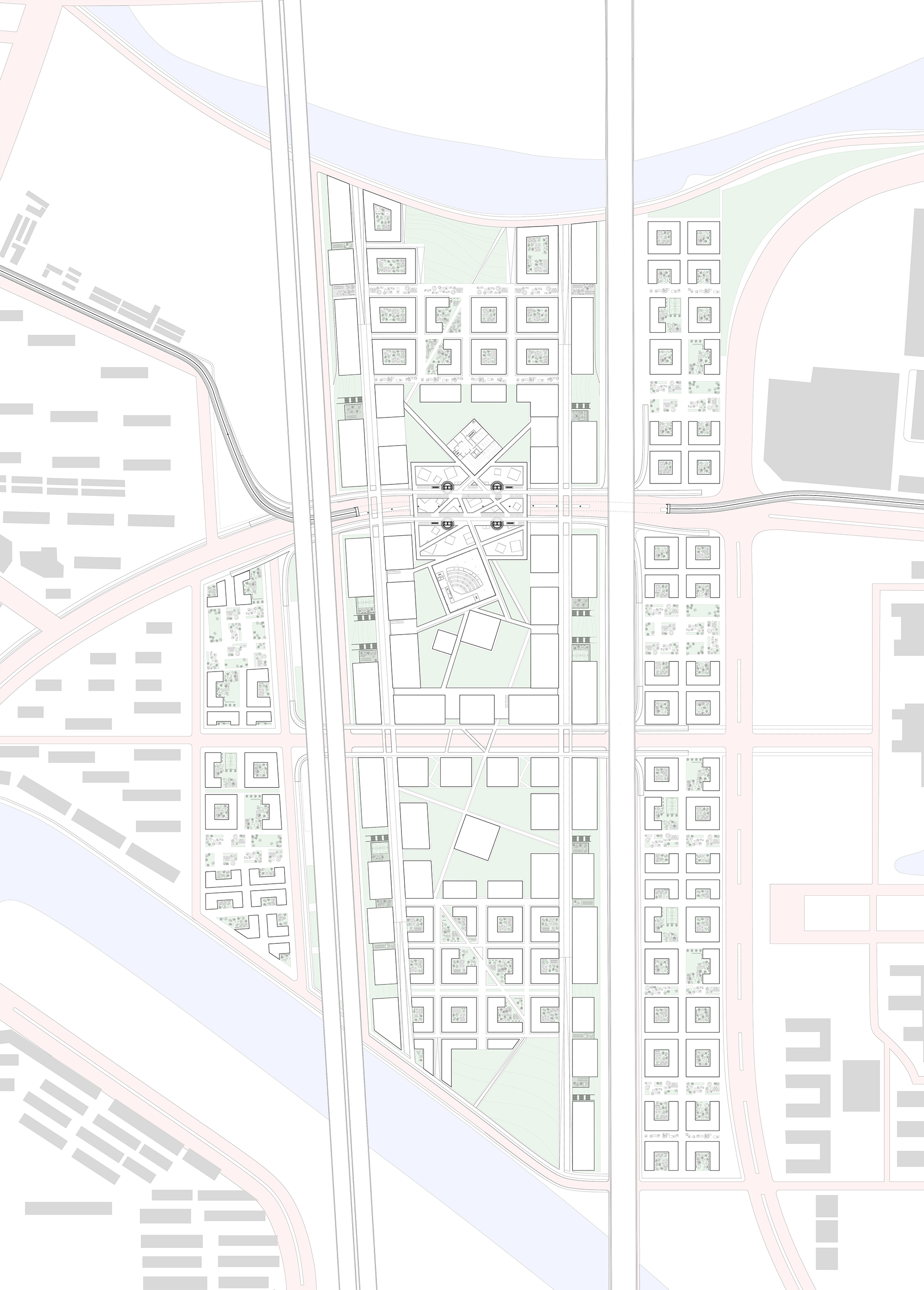
The monorail path starts from the central island of Longhu CBD with a connection to metro line 4 and ends up on the East side of the central island in the Longzihu University City, by connecting to metro line 8. In its middle, this monorail shares a transfer station with metro line 12, on the site of our major innovation park. The monorail has in total 8 stops. The distance between each station is around 1km to 1.5km. Also, along the monorail, 4 under-developed mega blocks were chosen to be developed as complexes combining innovation spaces with residential and commercial programs.
During the field trip, we found that the mega blocks in this newly built district lack a certain street life. The missing diversity of activities on the ground level is mostly resulting from the significant offset from the buildings from the street frontages. Both residential towers and office buildings in this area are isolated from the street frontages by a 10 to 20m offset which usually is filled with a green buffer or a gated fence.
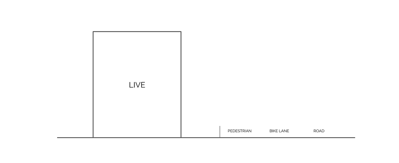
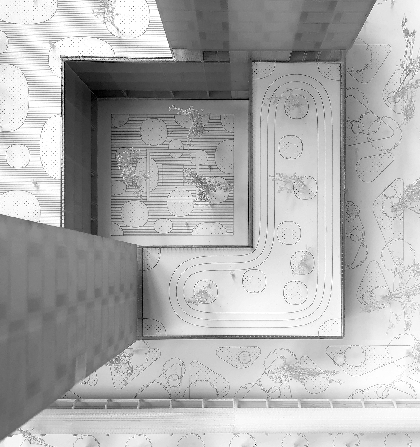
We would like to offer a new typology of buildings having a podium extending to the edge of the pedestrian streets, with commercial programs on the ground level, and innovation offices on the 4 to 5 remaining floors of the podium. 2 residential towers will sit on top of each block’s podium. At the center of the block, a courtyard offers a congregational space for the community of workers. The roof of the podium is vegetized and hosts a couple of semi-public programs, for the inhabitants of the residential towers.
This new type of courtyard-like structure divides the mega blocks into mini pedestrian grids. Within these mega blocks, more street frontages and pedestrian streets are created, and life is brought back to a previously empty neighborhood, all within walkable distance.
Site Strategy & Phases: A Grid For Innovation
Located almost halfway between the CBD and the University City, our main site stretches between an elevated railway corridor and an elevated highway. At the West of the site is a strip of empty land, and then the outskirts of the CBD. On the East, the University City begins. Our project aims at offering three key components:
(1) A reinforced cross-connectivity between the West and the East side of the site
(2) A vibrant innovation park, built over 3 main phases of development, and providing a flexible urban grid, that can allow for future development of the park
(3) A station, central to the project, that blends a certain efficiency of circulation with the aim of showcasing innovation.
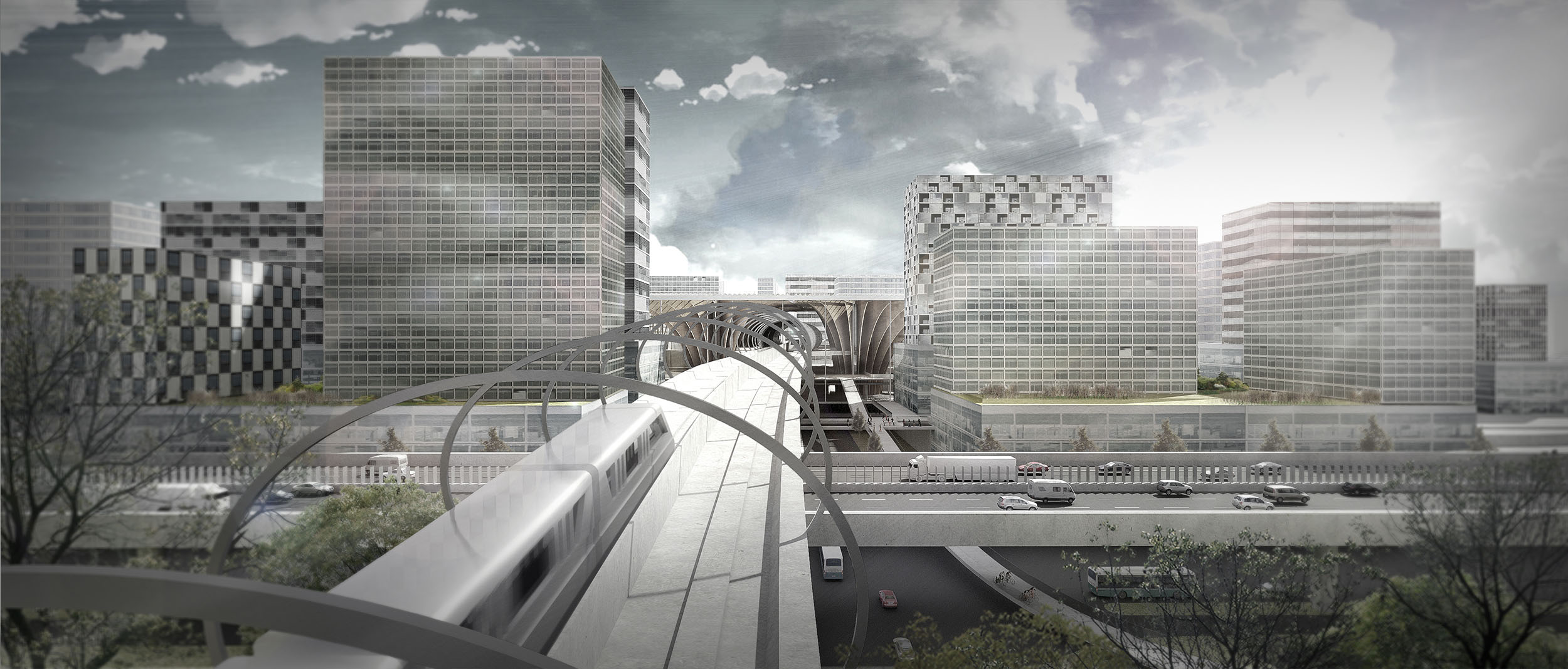
Reinforced cross-connectivity
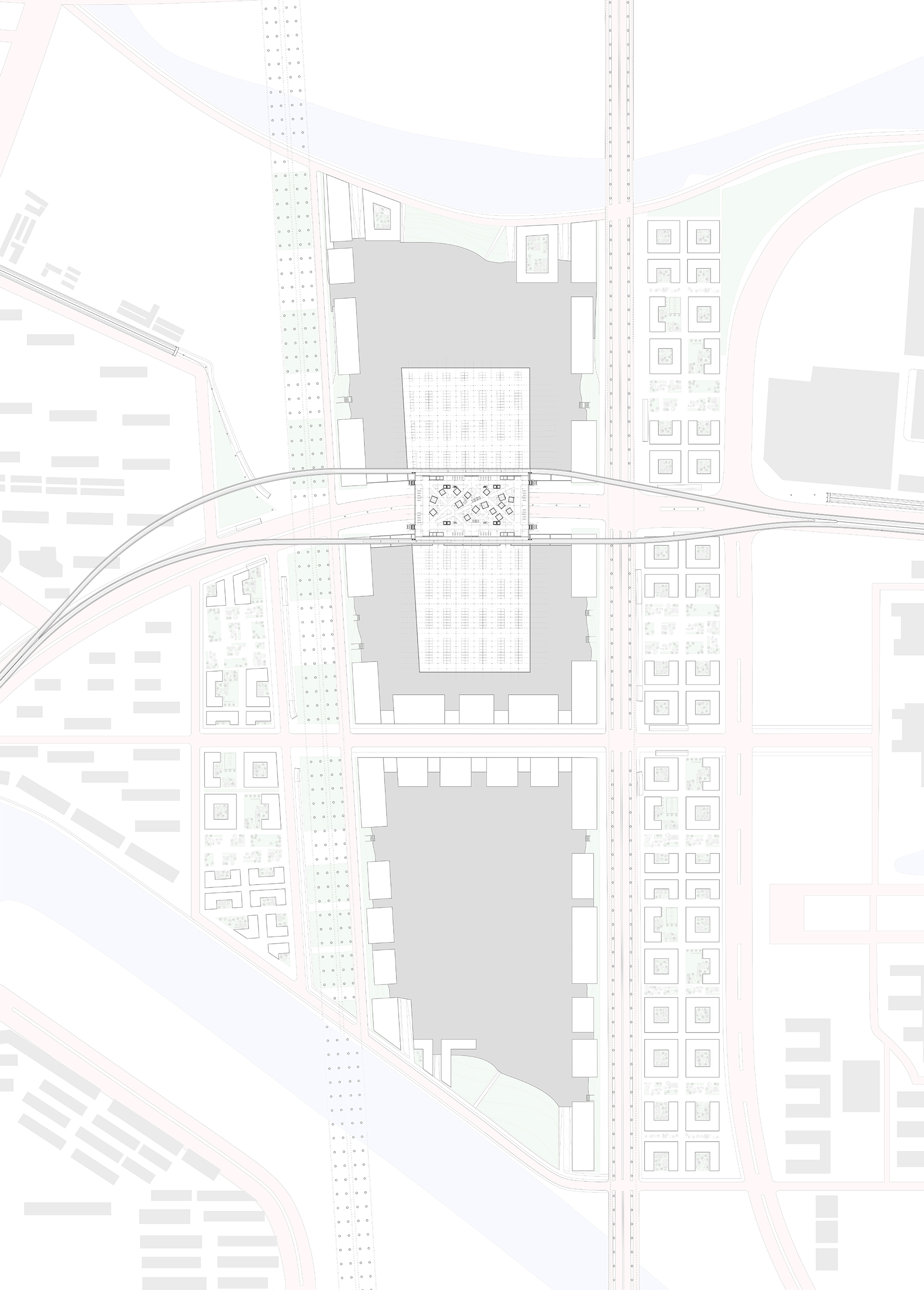
The monorail is first aligned on the preexisting spine, that traverses the site from West to East, and stops in the main station, elevated over the same spine. As the site is filled with a 6 to 7-meter-high layer of excavated earth, we rest our project on this natural plate, and construct ramps that bring pedestrians and bikes in the site. At the same time, we open a second vehicular spine, further South, that expands deep into the CBD and the University urban fabrics. The site being now split into 3 mega blocks of roughly 350 meters by 400 meters, we are left with walkable blocks, where circulation can be left to pedestrians and bikes only, while cars are welcomed in the site only through the two spines, and the sunken parking lots.
The bike lane ramps, the monorail and the pedestrian ramps bridge across the highway and the railway to connect on the West and East side, inviting the public into the program, while offering an easier and faster solution to cross the boundary formed by the railway/high edge.
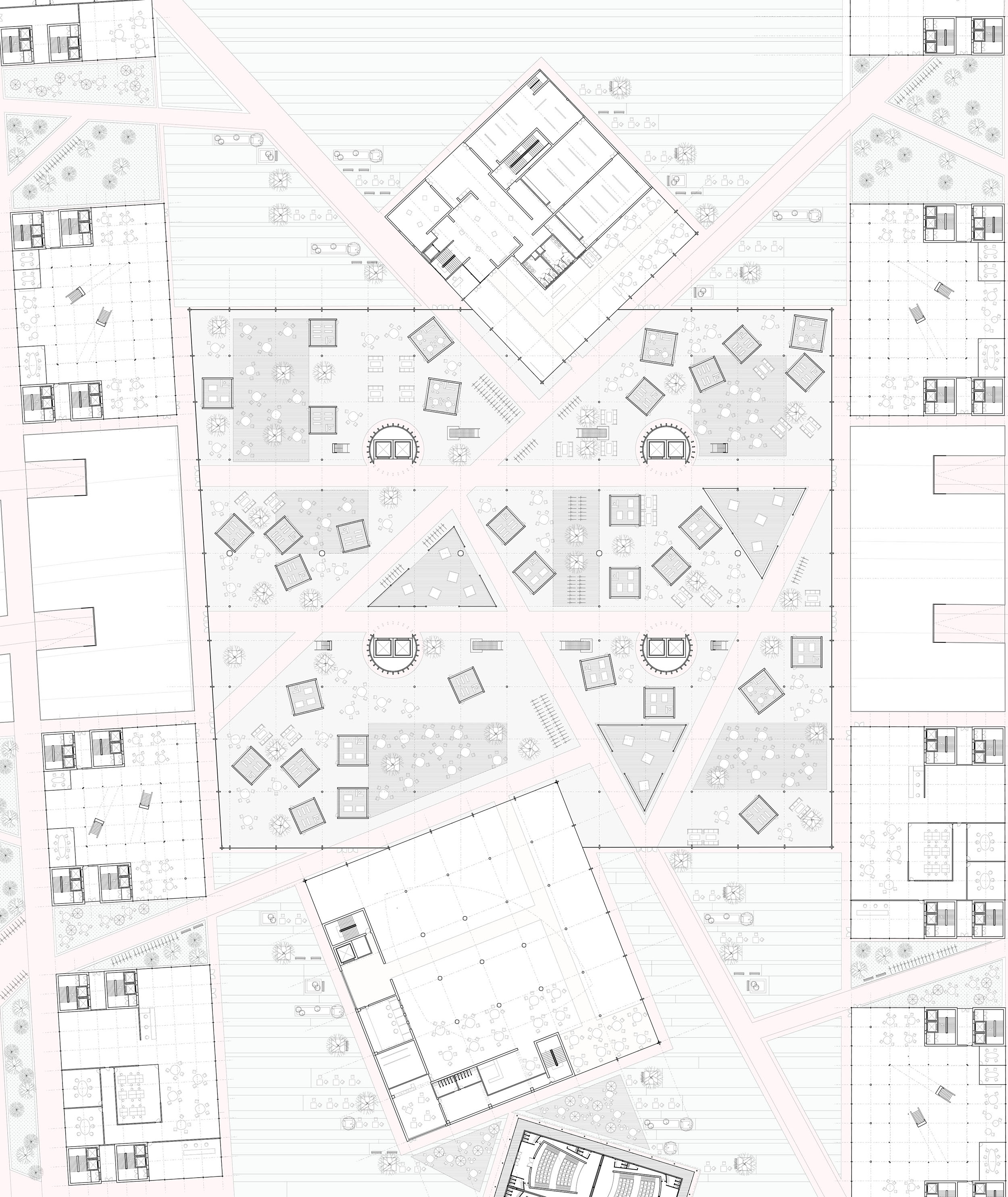
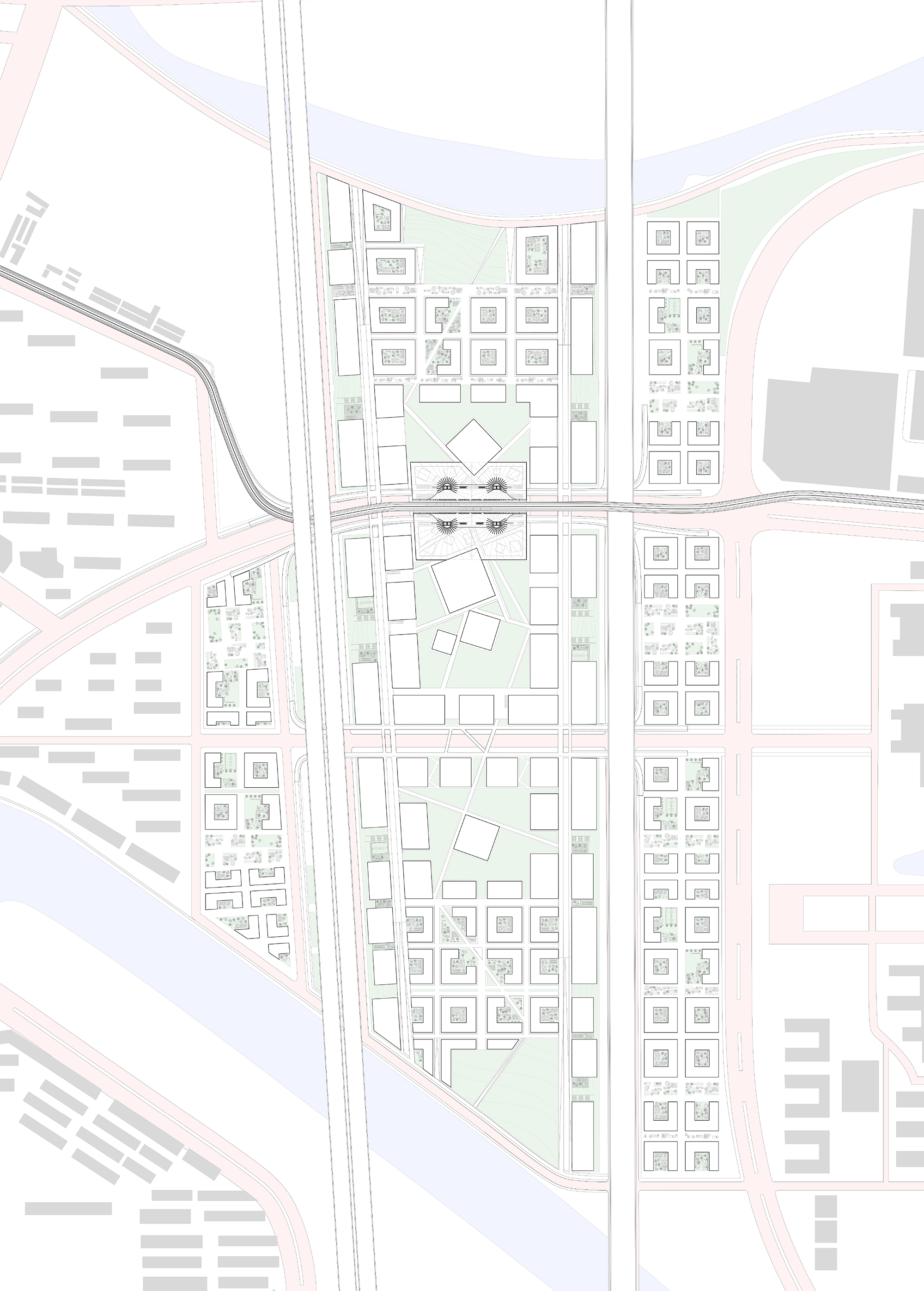
Phases and Grid
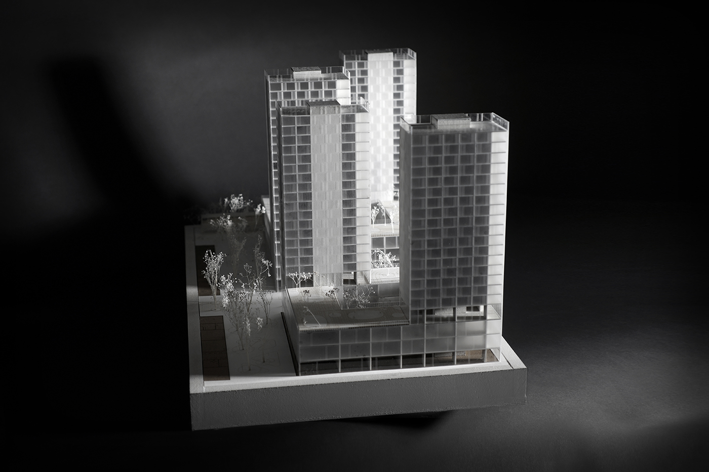
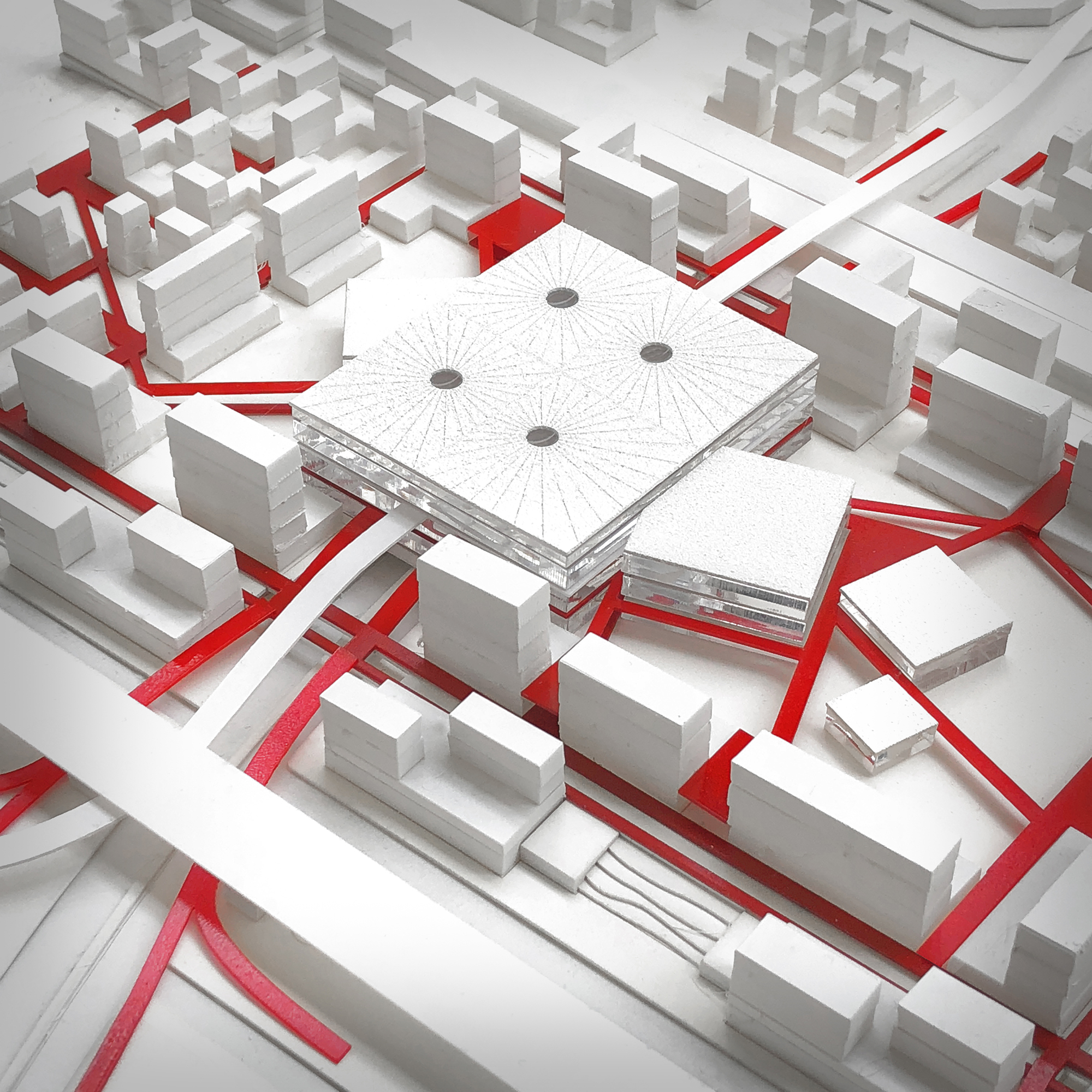
The project is therefore structured into 3 main mega blocks, connected by bike lanes and pedestrian bridges crossing above the 2 vehicular spines. Each block is porous and offers gaps between the buildings to allow for views from and to the project. The buildings themselves follow the same strategy as the one in the pockets: innovation podium and residential tower on top. The center of each mega block hosts a landscaped patio, and some public programs: a museum of innovation, and convention center, and public amphitheater. The museum and the convention center collide with the station in the central mega block, to form one large public complex, where commuters, tourists, and professionals are brought together to celebrate innovation and its multiple facets.
As the project is vast, we offer to phase out its development: the first step consists of the central mega block, the station, and surrounding public programs. The initial step is simply aiming at harvesting the potential of the new metro station while offering vibrant public facilities to attract a larger public and creating the first cluster of innovation. The second step extends this first mega block to the North and the South. This time the mega blocks fade into a grid structure. This grid with a block size of 50 meters by 50 meters, is strictly calibrated on the site constraints and inspired from the grid of the pockets. At the same time, a network of pedestrian and bike pathways break the regularity of the grid, to connect key places more efficiently while adding more serendipity to the grid. Key moments are then generated along these “breaks” of the grid to allow for more encounter and friction between workers present on the site.
The last phase offers to extend this grid to the other side of the railway and the highway. The gap left between our intervention, the CBD and the University is now filled with the same innovation grid. This last buffer adapts to alignments coming from our site and the urban fabric of both the CBD and the University City.
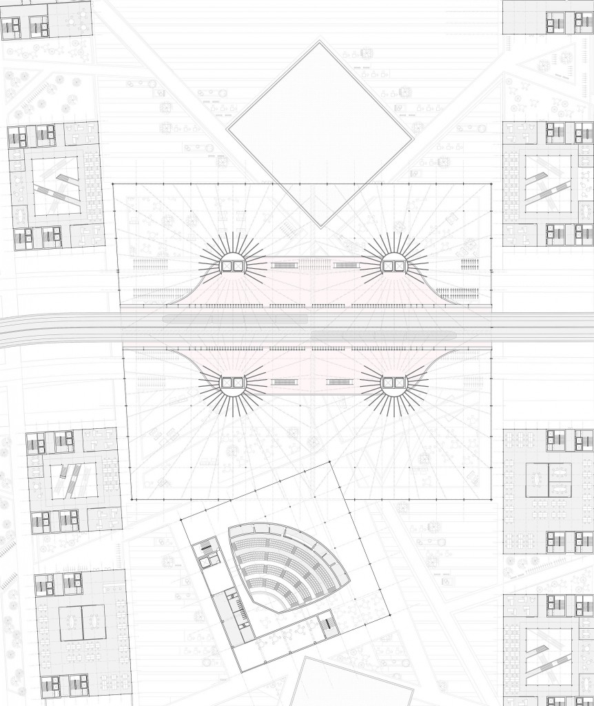
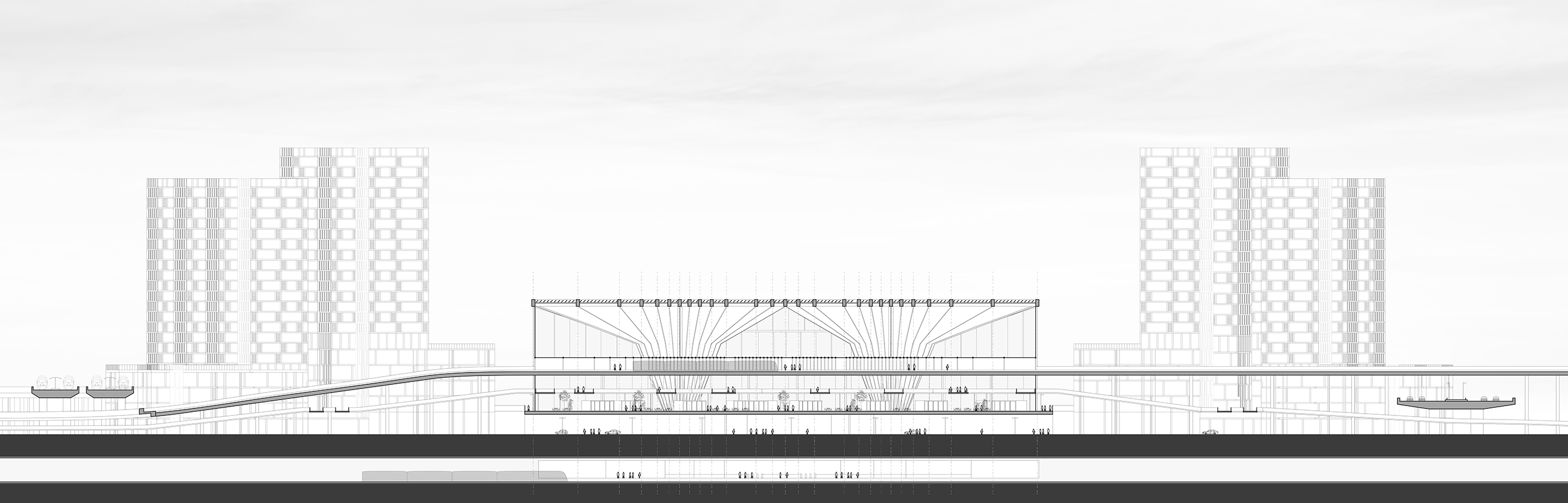
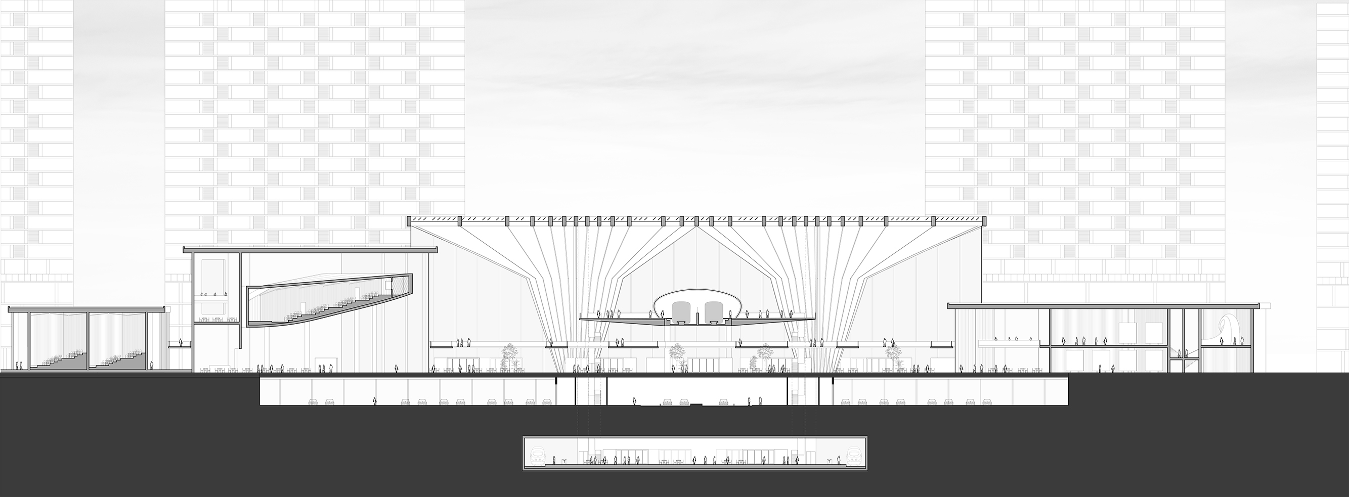
The Station: Connectivity & Innovation
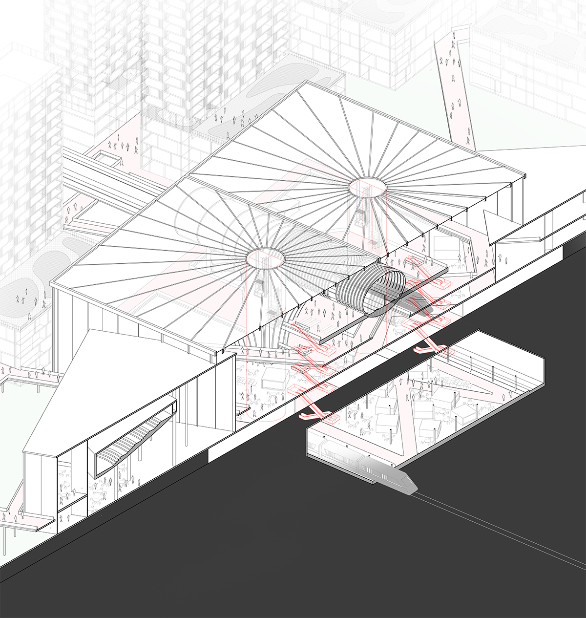
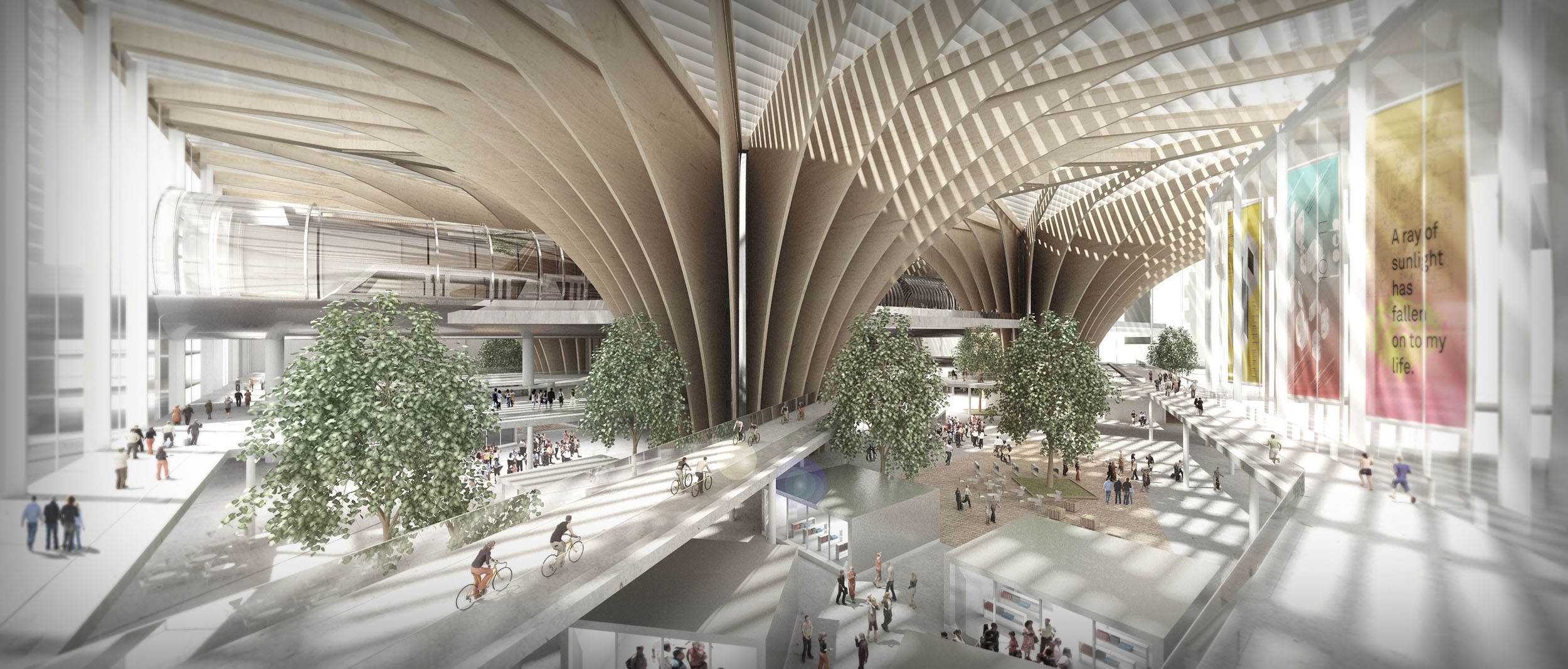
The station is the central piece of our strategy. It combines the imperative of efficiency with the need to showcase innovation to the greater public. We imagine a station that could deal with this challenge through a system of layers, that a vertical circulation of elevators and escalator would connect together. At the basement, the metro line 12 arrives in our site. The metro station already expresses the blend between efficiency and serendipity: the commuters arrive through standard metro platforms, to then discover a serendipitous layout of shops and public galleries, showcasing innovation. At the floor above, the vehicular spine traverses the site. Through a system of elevators and escalators, users bypass this layer, and directly arrive in the station itself, on the second floor. The main hall of the station enfolds under a large canopy, held by radial wooden vaults. The facade is fully glazed and the lights, filtered by stainless louvers bath the space during the day. The 2nd floor hosts a serendipitous layout of shops, restaurants and innovation counters, that showcase innovation. The space is then traversed by many bike and pedestrian lanes, that stem from the station and reach specific places of the site. Their chaotic intersection in the station transforms the mall-like second floor into a vibrant crossroad! The museum of innovation, as well as the convention center, can be entered at this floor too. As they penetrate the station by one of their angle, their presence is noticeable from any point in the station.
At the third floor, the bike and pedestrian ramps coming from the West and East of the site enter the station and merge with the network of bike lanes from the site. This interconnected web of lanes constitutes most of the third floor. The fourth and last floor of the station welcomes the monorail station. Simple and efficient, this last floor is connected to the rest of the station by elevators and escalators. Overall the station is the central node that ties the project together. It brings people to the site, and dispatches them across the project while inviting them to discover innovation.